

How Does GPS Know Where You Are?
Push a button and your phone or auto’s GPS unit shows where you are. But how did it know?
What Is GPS? GPS stands for Global Positioning System. Originally developed for the U.S. military, it consists of three key elements: a network of about 30 satellites, a control system to coordinate them and ground-
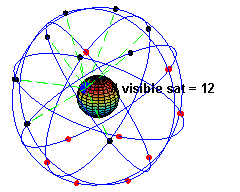
Signals Direct from Space. Day and night each GPS satellite transmits its position and the exact time. Their orbits are arranged so that at least four satellites are always visible from any point on Earth. The graphic shows how the blue dot on a rotating Earth is always connected with with several orbiting blue dots in space.
To Your GPS Receiver. Your GPS unit continuously receives signals from the satellites over your area; signals from more distant satellites take longer to arrive. These time differences, though miniscule, are measurable and the GPS receiver uses them to determine the exact time at your location (the receiver’s own clock is not accurate enough), the distance to each satellite and from that your latitude, longitude and altitude. The need for precise timekeeping is so great that the satellites’ clocks must be adjusted daily to compensate for the time effects of high speed and low gravity (Einstein’s laws of Special and General Relativity).
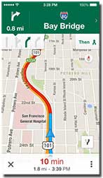
Plotted on a Map. The GPS signal itself provides only your location. To see where you are and where you want to go, your unit needs software that can plot your position on a digital map.
This is the realm of Google and others who use the GPS coordinates to show your location on a digital map. By tracking GPS coordinates over time, these systems can calculate your direction and speed. Coupled with destination and traffic data obtained separately, they provide directions and an estimated arrival time.
What Else Is GPS Used For? Usually we think of GPS for personal directions. But it is used for much, much more. For example farmers use it for “precision farming,” enabling localized application of fertilizer and pesticides, divers use GPS to mark spots they want to return to and surveyors use GPS to prepare maps and site plans.
* * * * *
GPS is but one example of how science and math affect daily life.
-----
- Image by El Pak from Wikipedia.
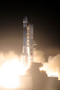
- Delta II rocket launching GPS satellite, August 2009. Source: U.S. Government.
This article originally appeared in our free semi-monthly newsletter. To receive future issues, please add your name to the subscription list.